-
 Blank version
 -
 With labels
 -
 Baneh district
 -
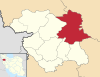 Bijar district
 -
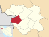
 Dehgolan district
 -
 Divandarreh district
 -
 Ghorveh district
 -
 Kamyran district
 -
 Marivan district
 -
 Sanandaj district
 -
 Saqqez district
 -
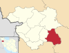
 Sarvabad district

Size of this PNG preview of this SVG file: 776 × 600 pixels. Other resolutions: 311 × 240 pixels | 621 × 480 pixels | 994 × 768 pixels | 1,280 × 989 pixels | 2,560 × 1,978 pixels | 1,980 × 1,530 pixels.
Original file (SVG file, nominally 1,980 × 1,530 pixels, file size: 3.33 MB)
| This is a file from the Wikimedia Commons. Information from its description page there is shown below. Commons is a freely licensed media file repository. You can help. |
Summary
| Description |
Map of Kurdistan Province and its districts. Colours from standard: Toolbox SVG locator maps (location map based)-en.svg |
|||
| Map legend |
Highlighted district Other countries (Iraq) |
|||
| Date | ||||
| Source | Own work and IranKurdistan-SVG.svg | |||
| Creator |
Isochrone and OpenStreetMap contributors |
|||
| Credit line | Isochrone & OSM contributors / Wikimedia Commons / CC-BY-SA 4.0 and ODbL | |||
| Permission (Reusing this file) |
This file is licensed under the Creative Commons Attribution-Share Alike Attribution-Share Alike 4.0 International, 3.0 Unported, 2.5 Generic, 2.0 Generic and 1.0 Generic license.
|
|||
| Geotemporal data | ||||
| Date depicted | 31 July 2021 | |||
| Map location | Kurdistan Province | |||
| Spatial reference system | Mercator | |||
| Bibliographic data | ||||
| Language | English | |||
| Archival data | ||||
| Notes | ||||
| SVG development | ||||
| Other versions |
|
|||
.svg)
.svg)


.svg)
.svg)