| Yonne | |
|---|---|
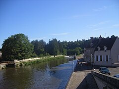
 The Yonne in Auxerre | |
 | |
| Location | |
| Country | France |
| Physical characteristics | |
| Source | |
| - location | Morvan |
| - elevation | 730 m (2,400 ft) |
| Mouth | |
| - location | Seine |
| - coordinates | 48°23′15″N 2°57′30″E / 48.38750°N 2.95833°E |
| Length | 292 km (181 mi) |
| Basin size | 10,887 km2 (4,203 sq mi) |
| Discharge | |
| - average | 95 m3/s (3,400 cu ft/s) |
| Basin features | |
| Progression | Seine→ English Channel |
The Yonne is a river in the northern half of France. It flows mainly through the western part of the Bourgogne-Franche-Comté region, giving its name to the Yonne department and to several communes. It is the main left tributary of the Seine river.
The river was named during the Roman Empire as Icauna, a Latin word that likely came from the Celtic name for the river.[1]
Geography
[change | change source]The Yonne river has a length of 292.3 km (181.6 mi) and a drainage basin with an area of 10,836 km2 (4,184 sq mi).[2]
Its average yearly discharge (volume of water which passes through a section of the river per unit of time) is 91.70 cubic metres per second at Courlon-sur-Yonne.[3]
 |
Course
[change | change source]The source of the Yonne is on the Prénely mountain on the southern end of the Morvan hills in the Glux-en-Glenne commune, Nièvre department, at an altitude of about 738 m (2,421 ft).[4]
.jpg)
The Yonne flows, in general, from the southeast to the northwest and passes through the 115 communes, most of them in the Bourgogne-Franche-Comté region; the main communes are:[2]
- Nièvre (58): Corbigny, Clamecy
- Yonne (89): Auxerre, Joigny, Sens, Pont-sur-Yonne, Villeneuve-sur-Yonne
- Seine-et-Marne (77): Montereau-Fault-Yonne
Finally, it flows, as a left tributary, into the Seine river in the town of Montereau-Fault-Yonne, at 47 m (154 ft) of altitude.[5]
Main tributaries
[change | change source]The main tributaries of the Yonne are:
- Left tributary
- Beuvron - 40.5 km;[6]
- Right tributaries
Gallery
[change | change source]-
 View of Auxerre and the Yonne
 -
 Sens on the Yonne river
 -
 Saint-Aubin-sur-Yonne and a bridge on the Yonne river
 -
 Clamecy and the Yonne river
 -
 Confluence at Montereau-Fault-Yonne, the Seine to the left and the Yonne to the right.

.jpg)


Related pages
[change | change source]References
[change | change source]- ↑ William Smith (1854). "Icaunas". Dictionary of Greek and Roman Geography. Retrieved 27 November 2014.
- ↑ 2.0 2.1 "L'Yonne (F3--0200)" (in French). SANDRE - Portail national d'accès aux référentiels sur l'eau. Archived from the original on 3 March 2016. Retrieved 27 November 2014.
- ↑ 3.0 3.1 "L'Yonne à Courlon-sur-Yonne (H2721010)" (in French). Banque Hydro. Archived from the original on 7 June 2016. Retrieved 21 June 2017.
- ↑ "Source de l'Yonne" (in French). Géoportail. Retrieved 27 November 2014.
- ↑ "Confluence de l'Yonne" (in French). Géoportail. Retrieved 27 November 2014.
- ↑ "Le Beuvron (F30-0400)" (in French). SANDRE - Portail national d'accès aux référentiels sur l'eau. Archived from the original on 10 June 2015. Retrieved 27 November 2014.
- ↑ "La Cure (F31-0400)" (in French). SANDRE - Portail national d'accès aux référentiels sur l'eau. Archived from the original on 10 July 2015. Retrieved 27 November 2014.
- ↑ "Le Serein (F32-0400)" (in French). SANDRE - Portail national d'accès aux référentiels sur l'eau. Archived from the original on 24 May 2015. Retrieved 27 November 2014.
- ↑ "L'Armancon (F3--0210)" (in French). SANDRE - Portail national d'accès aux référentiels sur l'eau. Archived from the original on 3 March 2016. Retrieved 27 November 2014.
- ↑ "La Vanne (F35-0400)" (in French). SANDRE - Portail national d'accès aux référentiels sur l'eau. Archived from the original on 3 March 2016. Retrieved 27 November 2014.
Other websites
[change | change source]- Banque Hydro - Station H2721010 - L'Yonne à Courlon-sur-Yonne (Synthèse) Archived 2016-06-07 at the Wayback Machine (in French)