Loir Le Loir (French) | |
---|---|
Etymology | From Gaulish ledo, "flow"[1] |
Nickname(s) | Loir sans E ("Loir-without-E")[2][3] |
Location | |
Country | France |
Physical characteristics | |
Source | |
- location | Perche |
- elevation | 150 m (490 ft) |
Mouth | |
- location | Sarthe |
- coordinates | 47°33′27″N 0°31′35″W / 47.55750°N 0.52639°W |
Length | 319 km (198 mi) |
Basin size | 8,270 km2 (3,190 sq mi) |
Discharge | |
- average | 33 m3/s (1,200 cu ft/s) |
The Loir is a river in central France. It is a left tributary of the Sarthe. It flows through two regions of France: Centre-Val de Loire and Pays de la Loire
The Eure-et-Loir and Loir-et-Cher departments are named after this river.
The Loir is 317.4 kilometres (197.2 miles) long. Its drainage basin covers 8,294 square kilometres (3,202 square miles).[4]
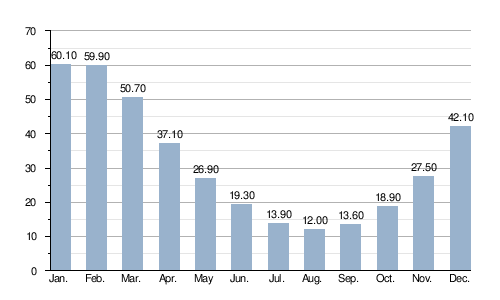
Its average yearly discharge (volume of water which passes through a section of the river per unit of time) is 31.70 m3/s (1,119 cu ft/s) at Durtal, Maine-et-Loire (1961 - 2017).[5]
Average monthly discharge (m3/s) at Durtal
The Loir starts in the former province of Perche, in the commune of Champrond-en-Gâtine, Eure-et-Loir department, Centre-Val de Loire region. It starts at an altitude of about 265 metres (869 feet).[6]
The Loir flows, in general, to the southwest. It goes through the following regions, departments and communes:[4]
At its end, the Loir flows into the Sarthe river at the place called Bec du Loir ("beak of the Cher")[N 1] in Briollay, Maine-et-Loire department, at 16 metres (52 feet) of altitude.[7]
The main tributaries of the Loir are:
Left tributaries:
|
|
Right tributaries:
|