| Creuse La Creuse (French) | |
|---|---|
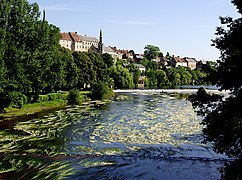
_-_Rivi%C3%A8re.jpg) La Creuse in Argenton-sur-Creuse | |
 | |
| Location | |
| Country | France |
| Physical characteristics | |
| Source | |
| - location | Plateau de Millevaches |
| - elevation | 932 m (3,058 ft) |
| Mouth | |
| - location | Vienne |
| - coordinates | 47°0′22″N 0°34′7″E / 47.00611°N 0.56861°E |
| Length | 263 km (163 mi) |
| Basin size | 9,570 km2 (3,690 sq mi) |
| Discharge | |
| - average | 81 m3/s (2,900 cu ft/s) |
The Creuse (Occitan: Cruesa) is a river in western France that flows through the Nouvelle-Aquitaine and Centre-Val de Loire regions.
It rises in the Massif Central and flows into the Vienne river, as a right tributary.
Geography
[change | change source]The Creuse river has a length of 236.6 km (147 mi) and a drainage basin with an area of approximately 10,279 km2 (3,969 sq mi).[1]
Its average yearly discharge (volume of water which passes through a section of the river per unit of time) is 74.0 m3/s (2,610 cu ft/s) at Leugny, Vienne.[2]

Average monthly discharge (m3/s) at Leugny
Course
[change | change source]The Creuse river starts in the Plateau de Millevaches, a north-western extension of the Massif Central, in the commune of Le Mas-d'Artige, Creuse department, at an elevation of about 811 m (2,661 ft).[3] From here, it generally flows to the northwest.
Finally, the river flows into the Vienne river, on the right side, in the place known as Bec des Deux Eaux in the communes Port-de-Piles (Vienne), Ports and Nouâtre (Indre-et-Loire).[4]
The Creuse flows through 5 departments and 80 communes, in 2 regions; some of the communes are:[1]
- Centre-Val de Loire region
- Indre: Argenton-sur-Creuse, Le Blanc
- Indre-et-Loire: Yzeures-sur-Creuse, Descartes
- Nouvelle-Aquitaine region
Main tributaries
[change | change source]The main tributaries of the Creuse river are:[1]
|
Left tributaries:
|
|
Right tributaries:
|
Gallery
[change | change source]-
 The Creuse in Yzeures sur Creuse
 -
 The Creuse in Argenton-sur-Creuse
 -
 The Creuse in Saint Gaultier
 -
 Confluence with the Gartempe river


Related pages
[change | change source]References
[change | change source]- ↑ 1.0 1.1 1.2 "La Creuse (L---0070)" (in French). SANDRE - Portail national d'accès aux référentiels sur l'eau. Archived from the original on 3 March 2016. Retrieved 31 July 2016.
- ↑ "La Creuse à Leugny" (in French). Banque Hydro. Archived from the original on 13 June 2018. Retrieved 29 July 2017.
- ↑ "Source de la Creuse" (in French). Géoportail. Retrieved 31 July 2016.[permanent dead link]
- ↑ "Confluence de la Creuse" (in French). Géoportail. Retrieved 31 July 2016.
Other websites
[change | change source]- Banque Hydro - Station L6020710 - La Creuse à Leugny Archived 2015-02-19 at the Wayback Machine (in French)