Bad Staffelstein | |
|---|---|
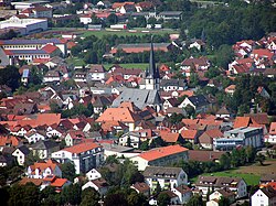
 Bad Staffelstein as seen from Staffelberg | |
| Coordinates: 50°06′N 10°58′E / 50.100°N 10.967°E | |
| Country | Germany |
| State | Bavaria |
| Admin. region | Oberfranken |
| District | Lichtenfels |
| Subdivisions | 20 Ortsteile |
| Government | |
| • Mayor (2018–24) | Jürgen Kohmann[1] (CSU) |
| Area | |
| • Total | 99.39 km2 (38.37 sq mi) |
| Elevation | 274 m (899 ft) |
| Population (2022-12-31)[2] | |
| • Total | 10,683 |
| • Density | 110/km2 (280/sq mi) |
| Time zone | UTC+01:00 (CET) |
| • Summer (DST) | UTC+02:00 (CEST) |
| Postal codes | 96231 |
| Dialling codes | 09573 |
| Vehicle registration | LIF, STE |
| Website | www.bad-staffelstein.de |
Bad Staffelstein is a small town in the Bavarian Administrative Region of Upper Franconia in Germany. It has about 10,000 residents.
Geography
[change | change source]Location
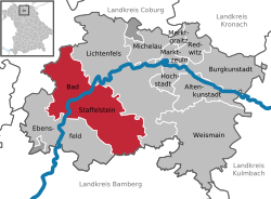
[change | change source]The municipal territory of Bad Staffelstein extends on both sides of the Main river. It is northeast of Bamberg in Lichtenfels.
Subdivisions
[change | change source]Bad Staffelstein consists of the following Stadtteile:
|
|
References
[change | change source]- ↑ Liste der ersten Bürgermeister/Oberbürgermeister in kreisangehörigen Gemeinden, Bayerisches Landesamt für Statistik, accessed 19 July 2021.
- ↑ Genesis Online-Datenbank des Bayerischen Landesamtes für Statistik Tabelle 12411-003r Fortschreibung des Bevölkerungsstandes: Gemeinden, Stichtag (Einwohnerzahlen auf Grundlage des Zensus 2011) .
- The information in this article is based on a translation of its German equivalent.
Further reading
[change | change source]Antiquarian
[change | change source]- Heinrich Karl, Staffelsteiner Chronik. Staffelstein 1905.
Modern
[change | change source]- Karl-Ludwig Ostertag-Henning, Der Apfelbaum im Gottesgarten. Staffelstein 1998, ISBN 3-9802943-6-6
- Bildende Kunst in Staffelstein. Hrsg. vom Arbeitskreis Kunst der Kultur-Initiative Staffelstein. Volume 1. Staffelstein 2000, ISBN 3-9802943-8-2
- Günter Dippold und Alfred Meixner (Hrsg.), Staffelsteiner Lebensbilder. Staffelstein 2000, ISBN 3-9802943-9-0
- Günter Dippold, Bad Staffelstein. Kleinod im Gottesgarten am Obermain. Stuttgart 2001, ISBN 3-09-303893-6
- Bildende Kunst in Staffelstein. Hrsg. vom Arbeitskreis Kunst der Kultur-Initiative Staffelstein. Volume 2. Bad Staffelstein 2002, ISBN 3-935302-01-0
Other websites
[change | change source]Wikimedia Commons has media related to Bad Staffelstein.
- Official website
 (in German)
| International | |
|---|---|
| National | |
| Geographic | |


