| Tagaytay |
|---|
|
Siyudad |
 |

Selyo | |
Lokasyon na Tagaytay |
 |
|
14°6′0″N 120°55′48″E |
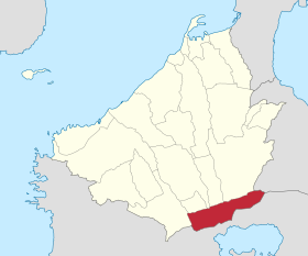
| Dalin |
Filipinas |
|---|
| Angipaletnegan |
Hunyo 21, 1938 |
|---|
| Barangay |
34 |
|---|
| Kaawang |
|---|
| • Katiponan |
65.00 km2 (25.10 sq mi) |
|---|
| Elebasyon |
292 m (958 ft) |
|---|
| Bilang na too (Mayo 1, 2020)[1] |
|---|
| • Katiponan |
85,330 |
|---|
| • Densidad |
1,300/km2 (3,400/sq mi) |
|---|
| Economia |
|---|
| • Clase |
kumadua ya klase a siyudad |
|---|
| • Ingresos |
₱1,270,453,684.95 (2020) |
|---|
| • Activos |
₱6,679,898,156.73 (2020) |
|---|
| • Pasivos |
₱1,764,264,036.73 (2020) |
|---|
| • Gastos |
₱1,249,554,254.36 (2020) |
|---|
| Kodigo na postal |
4120 |
|---|
| Kodigo na lugar |
46 |
|---|
| Website |
www.tagaytay.gov.ph |
|---|
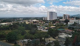
Say Tagaytay et kumadua ya klase a siyudad ed luyag na Cavite, Filipinas. Unong ed 1 Mayo 2020 census, say populasyon to et 85,330 totoo tan 22,399 abong. Walay kabaleg tan sukat to ya 65.00 sq. km. Say zip code to et 4120.
- Asisan
- Bagong Tubig
- Calabuso (Calabuso South & North)
- Dapdap East
- Dapdap West
- Francisco (San Francisco)
- Guinhawa North
- Guinhawa South
- Iruhin East
- Iruhin South
- Iruhin West
- Kaybagal East
- Kaybagal North
- Kaybagal South (Pob.)
- Mag-Asawang Ilat
- Maharlika East
- Maharlika West
- Maitim 2nd Central
- Maitim 2nd East
- Maitim 2nd West
- Mendez Crossing East
- Mendez Crossing West
- Neogan
- Patutong Malaki North
- Patutong Malaki South
- Sambong
- San Jose
- Silang Junction North
- Silang Junction South
- Sungay East
- Sungay West
- Tolentino East
- Tolentino West
- Zambal
Sensus na populasyon ed
Tagaytay| Taon | Pop. | ±% p.a. |
|---|
| 1939 | 1,657 | — |
|---|
| 1948 | 5,233 | +13.63% |
|---|
| 1960 | 7,203 | +2.70% |
|---|
| 1970 | 10,907 | +4.23% |
|---|
| 1975 | 13,388 | +4.20% |
|---|
| 1980 | 16,322 | +4.04% |
|---|
| 1990 | 23,739 | +3.82% |
|---|
| 1995 | 29,419 | +4.10% |
|---|
| 2000 | 45,287 | +9.69% |
|---|
| 2007 | 61,623 | +4.34% |
|---|
| 2010 | 62,030 | +0.24% |
|---|
| 2015 | 71,181 | +2.66% |
|---|
| 2020 | 85,330 | +3.63% |
|---|
| Reperensiya: Philippine Statistics Authority[2][3][4] |


