Wolfsthal
Coat of arms of Wolfsthal
Wolfsthal is located in Lower Austria
Wolfsthal
Wolfsthal
Location within Austria
Wolfsthal is located in Austria
Wolfsthal
Wolfsthal
Wolfsthal (Austria)
Coordinates: 48°8′N 17°0′E / 48.133°N 17.000°E / 48.133; 17.000
CountryAustria
StateLower Austria
DistrictBruck an der Leitha
Government
 • MayorGerhard Schödinger
Area
 • Total21.76 km2 (8.40 sq mi)
Elevation
150 m (490 ft)
Population
 (2018-01-01)[2]
 • Total1,032
 • Density47/km2 (120/sq mi)
Time zoneUTC+1 (CET)
 • Summer (DST)UTC+2 (CEST)
Postal code
2412
Area code02165
Websitewww.wolfsthal.at
Map

Wolfsthal is a town in the district of Bruck an der Leitha in Lower Austria in Austria. It along with neighboring Berg were part of the municipality of Wolfsthal-Berg until 1996. It is the end of the line for S7 Vienna S-Bahn trains.

Geography

The city is located next to the Danube river and Bratislava in Slovakia. It is part of the Industrial Quarter Industrieviertel in Lower Austria. The area of the municipality covers 21.78 square kilometers. 48.31 percent the area is forested.

History

Policy

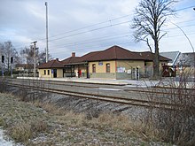
Wolfsthal train station

The mayor of the village is Gerhard Schödinger (ÖVP) and chief officer is Thomas Knaus. On 19 September 2007 Gerhard Schödinger won the Centrope Prize for his engagement in social integration of Slovak minority in Wolfsthal.

Population

Historical population
YearPop.±%
19231,039—    
1934921−11.4%
1939894−2.9%
1951864−3.4%
1961802−7.2%
1971795−0.9%
1973723−9.1%
1991711−1.7%
2001750+5.5%
2009833+11.1%
2010849+1.9%
2013896+5.5%
2014954+6.5%
2015947−0.7%
20161,001+5.7%
20171,006+0.5%
20181,032+2.6%
20191,094+6.0%
20201,146+4.8%

References

  1. ^ "Dauersiedlungsraum der Gemeinden Politischen Bezirke und Bundesländer - Gebietsstand 1.1.2018". Statistics Austria. Retrieved 10 March 2019.
  2. ^ "Einwohnerzahl 1.1.2018 nach Gemeinden mit Status, Gebietsstand 1.1.2018". Statistics Austria. Retrieved 9 March 2019.