| (({1))} |
|2=
|2=

The Andes (/ˈændiːz/ AN-deez), Andes Mountains or Andean Mountain Range (Spanish: Cordillera de los Andes; Quechua: Anti) are the longest continental mountain range in the world, forming a continuous highland along the western edge of South America. The range is 8,900 km (5,530 mi) long and 200 to 700 km (124 to 435 mi) wide (widest between 18°S and 20°S latitude) and has an average height of about 4,000 m (13,123 ft). The Andes extend from South to North through seven South American countries: Argentina, Chile, Bolivia, Peru, Ecuador, Colombia, and Venezuela.
Along their length, the Andes are split into several ranges, separated by intermediate depressions. The Andes are the location of several high plateaus—some of which host major cities such as Quito, Bogotá, Cali, Arequipa, Medellín, Bucaramanga, Sucre, Mérida, El Alto, and La Paz. The Altiplano Plateau is the world's second-highest after the Tibetan Plateau. These ranges are in turn grouped into three major divisions based on climate: the Tropical Andes, the Dry Andes, and the Wet Andes. (Full article...)
Selected general articles
-

Pomerape is a stratovolcano lying on the border of northern Chile and Bolivia (Oruro Department, Sajama Province, Curahuara de Carangas Municipality). It is part of the Payachata complex of volcanoes, together with Parinacota Volcano to the south. The name "Payachata" means "twins" and refers to their appearance. It hosts glaciers down to elevations of 5,300–5,800 metres (17,400–19,000 ft), lower on the northern slope.
Pomerape is a complex of lava domes, accompanied by lava flows which were emplaced atop of the domes. It was active about 200,000 years ago. The lava domes formed first and were later buried by the actual volcanic cone, which unlike the rhyolitic-dacitic domes is formed by hornblende andesite. The "Chungará Andesites" and lava dome complex of Parinacota were laid down at this time. Pomerape is associated with an adventive vent that has erupted mafic magmas. The main cone was last active 106,000 +- 7,000 years ago, the adventive vent is dated to 205,000 ± 24,000 years ago. (Full article...) -
Cabaraya is a stratovolcano in Bolivia. It lies between the volcanoes Isluga and Tata Sabaya, immediately east of the border with Chile. (Full article...) -
The Llao Llao Hotel is located in the tourist resort of San Carlos de Bariloche within the Río Negro, Argentina.
This famous hotel is situated in the foothills of the Andes on a hill between the Moreno Lake and Nahuel Huapi lakes. (Full article...) -
Chacaltaya (Mollo language for "bridge of winds" or "winds meeting point", Aymara for "cold road"[dubious – discuss]) is a mountain in the Cordillera Real, one of the mountain ranges of the Cordillera Oriental, itself a range of the Bolivian Andes. Its elevation is 5,421 meters (17,785 ft). Chacaltaya's glacier — which was as old as 18,000 years — had an area of 0.22 km2 (0.085 sq mi) in 1940, which had been reduced to 0.01 km2 (0.0039 sq mi) in 2007 and was completely gone by 2009. Half of the meltdown, as measured by volume, took place before 1980. The final meltdown after 1980, due to missing precipitation and the warm phase of El Niño, resulted in the glacier's disappearance in 2009. The glacier was located about 30 kilometers (19 mi) from La Paz, near Huayna Potosí mountain. (Full article...) -
Orestias chungarensis is a species of fish in the family Cyprinodontidae. It is endemic to Lake Chungara in Chile. (Full article...)
-

The Andean flicker (Colaptes rupicola) is a species of bird in subfamily Picinae of the woodpecker family Picidae. It is found in Argentina, Bolivia, Chile, Ecuador, and Peru. (Full article...) -
Sierra Nevada, also known as Sierra Nevada de Lagunas Bravas, is a major ignimbrite-lava dome complex which lies in both Chile and Argentina in one of the most remote parts of the Central Andes.
Activity in the complex started in Argentina and formed two stratovolcanoes. Later, 12 or more vents formed, some with craters up to 400 metres (1,300 ft) wide. Lava flows up to 7 kilometres (4.3 mi) long with flow ridges are also found. It covers a total area of 225 km2. Radiometric dating has yielded ages of 1.7 ± 0.4 to 0.431 ± 0.012 million years ago, a lava flow from the neighbouring Azufrera Los Cuyanos volcano that is sometimes considered part of Sierra Nevada is 140,000 years old. Together with Cerro el Condor and Peinado it forms the Culampaja line, a line of volcanoes that reaches Cerro Blanco. Strong seismic attenuation is observed beneath Sierra Nevada. Hydrothermally altered rocks in Sierra Nevada may be the source of sulfate and arsenic in the Juncalito and Negro rivers, and heat sources for regional hot springs. The snowline in the area lies at 5,800 metres (19,000 ft) altitude at Cumbre del Laudo. (Full article...) -
Illimani is a mountain in the Khari Khari mountain range of the Bolivian Andes, about 5,030 m (16,503 ft) high. It is situated south-east of Potosí in the Potosí Department, Tomás Frías Province, Potosí Municipality. Illimani lies south-west of the mountain Uma Jalanta, north-east of Challwiri Lake and north of Illimani Lake. (Full article...)
-
Mount Darwin (Spanish: Monte Darwin) is a peak in Isla Grande de Tierra del Fuego forming part of the Cordillera Darwin, the southernmost range of the Andes, just to the north of the Beagle Channel. It is 2,438 m (7,999 ft) high.
Monte Darwin was for a long time considered as the highest peak in Tierra del Fuego, but that distinction corresponds to a nearby mountain unofficially named Monte Shipton (also somewhat confusingly referred to as Darwin or Agostini-Darwin), which is about 2,580 m (8,460 ft) high and is located at . Both peaks are best climbed in late December, January, February and March. Monte Shipton was first climbed in 1962 by Eric Shipton, E. Garcia, F. Vivanco and C. Marangunic. (Full article...) -
Rondoy (possibly from Quechua runtuy: "to hail" or "to lay an egg") is a 5,870-metre-high (19,259 ft) mountain in the north of the Huayhuash mountain range in the Andes of Peru. It is located in the Ancash Region, Bolognesi Province, Pacllón District, and in the Huánuco Region, Lauricocha Province, Queropalca District. Rondoy lies north of Yerupajá and Jirishanca and southwest of Lake Mitococha. (Full article...) -
Yerupaja Chico is a mountain in Peru.
Yerupaja Chicho rises 6,121 metres (20,082 ft) and neighboring Yerupaja rises 6,617 metres (21,709 ft). The names' literal translations are yerupaja – smaller and yerupaja – larger. They are two peaks in the Peruvian Andes. They can be viewed from above Laguna Solteracocha on the way up to Punta Sambuya on trekking trails through the Huayhuash. Chico is claimed to be a technically more difficult project for mountain climbers, although it is approximately 600 metres lower. (Full article...) -
Tronador (Spanish: Cerro Tronador) is an extinct stratovolcano in the southern Andes, located along the border between Argentina and Chile, near the Argentine city of Bariloche. The mountain was named Tronador (Spanish for "Thunderer") by locals in reference to the sound of falling seracs. With an altitude of 3,470 metres (11,380 ft), Tronador stands more than 1,000 m above nearby mountains in the Andean massif, making it a popular mountaineering destination. Located inside two national parks, Nahuel Huapi in Argentina and Vicente Pérez Rosales in Chile, Tronador hosts a total of eight glaciers, which are currently retreating due to warming of the upper troposphere. (Full article...) -
Paquni (Aymara paqu a kind of edible herb, -ni a suffix, "the one with the paqu herbs", Hispanicized spelling Pacuni) is a 4,838-metre-high (15,873 ft) mountain in the Potosí Department of Bolivia. It is located in the Antonio Quijarro Province, Tomave Municipality, northeast of the Jatun Mundo Quri Warani volcano. (Full article...)
-
Doña Juana (Spanish: Volcán Doña Juana) is a stratovolcano, located within the Doña Juana-Cascabel Volcanic Complex National Natural Park (Spanish: Parque Nacional Natural Complejo Volcánico Doña Juana-Cascabel) in Nariño, Colombia.
With a previous eruption of VEI 4, Doña Juana is rated as a "large" volcano of "cataclysmic" destructive power. During its last eruption, in 1906, more than 100 people were killed and many houses were destroyed. (Full article...) -
Huandoy (probably from Quechua wantuy, to transfer, to transpose, to carry, to carry a heavy load) or Tullparaju (possibly from Quechua tullpa rustic cooking-fire, stove, rahu snow, ice, mountain with snow) is a mountain located inside Huascarán National Park in Ancash, Peru. It is the second-tallest peak of the Cordillera Blanca section of the Andes, after Huascarán. These two peaks are rather nearby, separated only by the Llanganuco glacial valley (which contains the Llanganuco Lakes) at 3,846 m asl.
It is a snow-capped mountain with four peaks arranged in the form of a fireplace, the tallest of which is 6,395 m. The four peaks are each over 6,000 m, and are:- Huandoy (6,395 m)
- Huandoy-West (6,356 m)
- Huandoy-South (6,160 m)
- Huandoy-East (6,000 m)
-
The Nevado del Tolima is a Late Pleistocene to recently active andesitic stratovolcano located in the Tolima department, Colombia. The volcano lies south of Nevado del Ruiz volcano and is situated within the Los Nevados National Natural Park. The volcano, whose most recent activity dates to 1943 and last major eruption around 3600 years ago, overlies the Eocene El Bosque Batholith, dated at 49.1 ± 1.7 Ma. (Full article...) -
Nahuel Huapi National Park (Spanish: Parque Nacional Nahuel Huapi) is the oldest national park in Argentina, established in 1922 as Parque Nacional de Sud and reconfiguered in 1934. It surrounds Nahuel Huapi Lake in the foothills of the Patagonian Andes. The largest of the national parks in the region, it has an area of 7,050 km2 (2,720 sq mi), or nearly 2 million acres. Its landscapes represent the north Patagonian Andean Zone consisting of three types, namely, the Altoandino (with perpetual snow above an altitude of 1,600 metres (5,200 ft)), the Andino-Patagónico (in the lower reaches of the hills) and the Patagonian steppe. It also represents small parts of the Valdivian Rainforest.
The park and the reserve lie at an altitude of 720–3,574 metres (2,362–11,726 ft), and are designated under IUCN management categories II (National Park) and IV (Management Reserve). The park is completely protected while the reserve is partially protected. The national park is dominated by the high mountain chain of the Andes, many lakes, rapid rivers, waterfalls, snow-clad peaks, glaciers and extensive forests. It is bordered by Chile on its western side. (Full article...) -
Chumpe (possibly from chumpi Jaqaru for corn with yellow seeds and Quechua for belt; or ch'umpi Jaqaru for red and Quechua for brown), is a mountain in the north of the Pariacaca mountain range in the Andes of Peru, about 5,200 metres (17,060 ft) high. It is situated in the Junín Region, Yauli Province, in the districts of Huay-Huay and Yauli District. Chumpe lies east of Lake Pumacocha. The mining town of San Cristóbal is situated at its feet. (Full article...) -
Touching the Void is a 1988 book by Joe Simpson, recounting his and Simon Yates's near fatal descent after climbing the 6,344-metre (20,814 ft) peak Siula Grande in the Peruvian Andes. Approximately 15% of the book is written by Yates. It has sold over a million copies and has been translated into over 20 languages. (Full article...)
-
Acotango is the central and highest of a group of stratovolcanoes straddling the border of Bolivia and Chile. It is 6,052 metres (19,856 ft) high. The group is known as Kimsa Chata and consists of three mountains: Acotango, Umurata (5,730 metres (18,799 ft)) north of it and Capurata (5,990 metres (19,652 ft)) south of it.
The group lies along a north–south alignment. The Acotango volcano is heavily eroded, but a lava flow on its northern flank is morphologically young, suggesting Acotango was active in the Holocene. Later research has suggested that lava flow may be of Pleistocene age. Argon-argon dating has yielded ages of 192,000±8,000 and 241,000±27,000 years on dacites from Acotango. Glacial activity has exposed parts of the inner volcano, which is hydrothermally altered. Glacial moraines lie at an altitude of 4,200 metres (13,800 ft) but a present ice cap is only found past 6,000 metres (20,000 ft) of altitude. (Full article...) -
Parinacota (in Hispanicized spelling), Parina Quta or Parinaquta is a dormant stratovolcano on the border of Bolivia and Chile. Together with Pomerape it forms the Nevados de Payachata volcanic chain. Part of the Central Volcanic Zone of the Andes, its summit reaches an elevation of 6,380 metres (20,930 ft) above sea level. The symmetrical cone is capped by a summit crater with widths of 1 kilometre (0.62 mi) or 1,000 metres (3,300 ft). Farther down on the southern slopes lie three parasitic centres known as the Ajata cones. These cones have generated lava flows. The volcano overlies a platform formed by lava domes and andesitic lava flows.
The volcano started growing during the Pleistocene and formed a large cone. At some point between the Pleistocene and the Holocene, the western flank of the volcano collapsed, generating a giant landslide that spread west and formed a large, hummocky landslide deposit. The avalanche crossed and dammed a previously existing drainage, impounding or enlarging Lake Chungará; numerous other lakes now forming the headwaters of the Rio Lauca sprang up within the deposit. Volcanic activity rebuilt the cone after the collapse, cancelling out the collapse scar. (Full article...) -
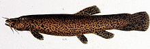
Trichomycterus rivulatus is a species of pencil catfish that is native to high-altitude Andean streams and lakes (including Junin, Poopó and Titicaca) in southern Peru, western Bolivia and northern Chile. It is the largest species in the genus Trichomycterus and grows to a maximum length of 37.4 centimetres (14.7 in) TL. The species is regularly caught as a food fish. However, because of pollution, studies have revealed levels of metals in T. rivulatus of Lake Titicaca that exceed the internationally recommended safety thresholds for human consumption. (Full article...) -
Nevado Tres Cruces is a massif of volcanic origin in the Andes Mountains on the border of Argentina and Chile. It has two main summits, Tres Cruces Sur at 6,748 metres (22,139 ft) and Tres Cruces Centro at 6,629 m (21,749 ft) and a third minor summit, Tres Cruces Norte 6,030 m (19,780 ft). Tres Cruces Sur is the sixth highest mountain in the Andes.
The volcano has an extended history of activity, going back at least 1.5 million years. A number of lava domes surround the complex and a number of craters lie on its summits. The main volcano is of rhyodacitic composition and has generated two major ignimbritic eruptions, one 1.5 million years ago and a second 67,000 years ago. The last eruption was 28,000 years ago, but the volcano is a candidate source for a Holocene eruption and could erupt again in the future. (Full article...) -
-
Illampu is the fourth highest mountain in Bolivia. It is located in the northern section of the Cordillera Real, part of the Andes, east of Lake Titicaca. It lies just north of the slightly higher Janq'u Uma, near the town of Sorata. Laguna Glaciar, located in the Illampu-Janq'u Uma massif, is the 17th highest lake in the world.
Despite being lower than Janq'u Uma, Illampu has a steeper peak, with more local relief, and is a somewhat harder climb. In fact it has "the hardest normal route on any of the 6,000 metre peaks in Bolivia." The easiest route, by the Southwest Ridge, is rated AD (Fairly Difficult), with snow slopes up to 65 degrees. It is accessed from a high camp on the north side of the massif. The peak was first climbed on June 7, 1928 via this route, by Hans Pfann, Alfred Horeschowsky, Hugo Hörtnagel (Germans) and Erwin Hein (Austrian). Other routes include the "German Route" on the southwest face and the South Face route, both approached from the west side of the massif. (Full article...)


.jpg)


com.jpg)


.jpg)
Did you know...
- ... that the 1930s Polish Andean expeditions have been credited with several first ascents and the tracing of a new route to the summit of Aconcagua, the Andes' highest peak?
Need help?
Do you have a question about Andes that you can't find the answer to?
Consider asking it at the Wikipedia reference desk.
Selected images
-
 Bolivian Andes (from Andes)
 -

-

-

-

-

-

-
 A male Andean cock-of-the-rock, a species found in humid Andean forests and the national bird of Peru (from Andes)
 -
 Pico Humboldt at sunset (from Andes)
 -
 Irrigating land in the Peruvian Andes (from Andes)
 -
 Laguna de Sonso tropical dry forest in Northern Andes (from Andes)
 -

-
 Nevado del Huila, Colombia (from Andes)
 -

-

-
 Peruvian farmers sowing maize and beans (from Andes)
 -
 Aerial view of Valle Carbajal in the Tierra del Fuego. The Andes range is about 200 km (124 mi) wide throughout its length, except in the Bolivian flexure where it is about 640 kilometres (398 mi) wide. (from Andes)
 -
 View of Cuernos del Paine in Torres del Paine National Park, Chile (from Andes)
 -
 Central Andes (from Andes)
 -

-
 Frederic Edwin Church, Heart of the Andes, 1859. (from Andes)
 -

-
 Parinacota, Bolivia/Chile (from Andes)


.jpg)


.jpg)


%E2%80%93Valle_Carbajal_01.jpg)


.jpg)


Subcategories

- Select [►] to view subcategories
Subtopics
Associated Wikimedia
The following Wikimedia Foundation sister projects provide more on this subject:
-
 Commons
Free media repository -
 Wikibooks
Free textbooks and manuals -
 Wikidata
Free knowledge base -
 Wikinews
Free-content news -
 Wikiquote
Collection of quotations -
 Wikisource
Free-content library -
 Wikiversity
Free learning tools -
 Wiktionary
Dictionary and thesaurus
-->