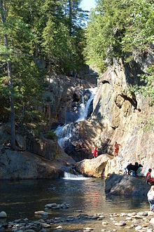
| Smalls Falls | |
|---|---|
 Smalls Falls, in Maine | |
 | |
| Location | Franklin County, Maine, United States |
| Coordinates | 44°51′31″N 70°31′00″W / 44.85860°N 70.51655°W |
| Type | Tiered |
| Total height | 16.5 m (54 ft) |
| Number of drops | 4 |
| Longest drop | 7.6 m (25 ft) |
Smalls Falls, a waterfall in Maine, is a series of waterfalls and cascades on the Sandy River[1] in Township E, West Central Franklin, Maine, in the United States. It totals 54 feet (16 m) in height, and consists of (from top to bottom) a 12-foot slide/horsetail, a 25-foot segmented waterfall, a 14-foot horsetail, and a 3-foot cascade, separated by pools.[2] A rest area on Maine Route 4 provides access to the falls;[3] the rest area includes pit toilets, parking and picnic tables.