This article needs additional citations for verification. Please help improve this article by adding citations to reliable sources. Unsourced material may be challenged and removed.Find sources: "Mac-Mac Falls" – news · newspapers · books · scholar · JSTOR (March 2023) (Learn how and when to remove this message)
| Mac-Mac Falls | |
|---|---|
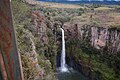
.jpg) Mac-Mac Falls | |
 | |
| Location | Mac-Mac Forest Nature Reserve, Mpumalanga, South Africa |
| Coordinates | 25°00′02″S 30°48′58″E / 25.00056°S 30.81611°E |
| Total height | 65 metres (213 ft) |
| Number of drops | 1 |
| Watercourse | Mac-Mac River |
The Mac-Mac Falls is a 65-metre waterfall on the Mac-Mac River in the Mac-Mac Forest Nature Reserve, Mpumalanga, South Africa.
History
[edit]Originally, the waterfall had a single stream, but miners used dynamite on the waterfall in the hopes of exposing the gold-rich reef, which now has the water falling in two streams.[1]
It was declared a Provincial Heritage Site February 18, 1983, along with the indigenous forest in the kloof below the waterfall.[2]
Gallery
[edit]-
-
-
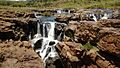 Mac-Mac Pools.
 -
_(31834893937).jpg)
_(31834733507).jpg)


See also
[edit]Wikimedia Commons has media related to Mac-Mac Falls.
References
[edit]- ^ "Mac Mac Falls: Sabie Gallery". www.sabie.co.za. Retrieved 17 March 2023.
- ^ "Mac Mac Waterfalls, Geelhoutboom, Pilgrim's Rest District | SAHRA". SAHRA. Retrieved 17 March 2023.
Lists of South African Heritage Resources | ||||||||||||||||||||
|---|---|---|---|---|---|---|---|---|---|---|---|---|---|---|---|---|---|---|---|---|
| SAHRA Heritage sites |
|  | ||||||||||||||||||
| World heritage sites | ||||||||||||||||||||