Highway 66 shield))
Highway 66
כביש 66
Tel megido.JPG
Route information
Length17 km (11 mi)
Existed1929–present
Location
CountryIsrael
Highway system
Highway 65 Highway 70

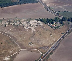
Highway 66 (Hebrew: כביש 66) is a north–south highway in the Jezreel Valley in northern Israel.

History

Highway 66 extends along the eastern lowlands below the Menashe Heights and the Carmel. It is 17 kilometres (11 mi) long. In the past the road continued south to Jenin, but today it ends at checkpoint. The northern section of the highway was constructed in 1929 to allow access to Tel Megiddo archaeological site for the anticipated visit of John D. Rockefeller Jr. The southern section was constructed in the 1930s, and the highway opened to general traffic between Haifa and Jenin in 1936 as a bypass road avoiding Nazareth.

Interchanges & junctions (south to north)

Kilometers Name type Location Intersecting routes
Green Line
NO northbound through-traffic for green (Palestinian Authority) license plates
Salem Security Checkpoint[1]
0 checkpoint Salem,
Zububa
1 Givat Oz Junction Giv'at Oz entrance road
3 Megiddo junction Megiddo Highway 65
4.8 Megiddo local road
5.5 HaYogev Junction HaYogev local road
7.4 Midrakh Oz Junction Midrakh Oz local road
10 Mishmar Ha'Emek Junction Mishmar Ha'Emek Route 6953
14 HaZore'a Junction HaZore'a local road
17 HaTishbi Junction Yokneam Route 722
18 Tel Kashish Interchange
Yokneam Highway 6
Highway 77

Landmarks

See also

References

  1. ^ "Checkpoints in the West Bank and Gaza". B’Tselem. 2019-09-25. Retrieved 2020-08-18.
  2. ^ "Tel Megiddo National Park". The Israel Nature and Parks Authority. Retrieved 2020-08-18.

32°37′14″N 35°08′13″E / 32.62056°N 35.13694°E / 32.62056; 35.13694