Gadmen | |
|---|---|
 Valley of Gadmen | |
| Country | Switzerland |
| Canton | Berne |
| District | Oberhasli |
| Government | |
| • Mayor | Barbara Kehrli |
| Area | |
| • Total | 116.4 km2 (44.9 sq mi) |
| Elevation | 1,205 m (3,953 ft) |
| Population (December 2007) | |
| • Total | 273 |
| • Density | 2.3/km2 (6.1/sq mi) |
| Time zone | UTC+01:00 (Central European Time) |
| • Summer (DST) | UTC+02:00 (Central European Summer Time) |
| Postal code(s) | 3863 |
| SFOS number | 0781 |
| ISO 3166 code | CH-BE |
| Surrounded by | Engelberg (OW), Göschenen (UR), Guttannen, Innertkirchen, Oberwald (VS), Wassen (UR) |
| Twin towns | Volketswil (Switzerland) |
| Website | www SFSO statistics |


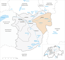
Gadmen is a municipality in the district of Oberhasli in the canton of Bern in Switzerland.
The name Gadmen comes from the Old High German "gadum," meaning barn or small house, and was first mentioned in 1382.
The municipality is in a municipal partnership with Volketswil in the Canton of Zürich.
History
Gadmen is first mentioned in 1382 as im Gadmen.[1]
Demographics
Gadmen has a population (as of 2007[update]) of 250, of which 2.8% are foreign nationals. Over the last 10 years the population has decreased at a rate of -15.5%. Most of the population (as of 2000[update]) speaks German (98.5%), with French being second most common ( 0.4%) and Spanish being third ( 0.4%).
In the 2007 election the most popular party was the SVP which received 52.4% of the vote. The next three most popular parties were the SPS (22.1%), the FDP (13.6%) and the local small left-wing parties (4.6%).
The age distribution of the population (as of 2000[update]) is children and teenagers (0-19 years old) make up 21.3% of the population, while adults (20-64 years old) make up 53.7% and seniors (over 64 years old) make up 25%. The entire Swiss population is generally well educated. In Gadmen about 51.1% of the population (between age 25-64) have completed either non-mandatory upper secondary education or additional higher education (either University or a Fachhochschule).
Gadmen has an unemployment rate of 1.12%. As of 2005[update], there were 52 people employed in the primary economic sector and about 21 businesses involved in this sector. 13 people are employed in the secondary sector and there are 3 businesses in this sector. 43 people are employed in the tertiary sector, with 13 businesses in this sector.[2] The historical population is given in the following table:[1]
| year | population |
|---|---|
| 1764 | 354 |
| 1850 | 739 |
| 1900 | 672 |
| 1950 | 485 |
| 1960 | 510 |
| 2000 | 272 |
Geography
Gadmen has an area of Template:Km2 to mi2. Of this area, 9.2% is used for agricultural purposes, while 15.2% is forested. Of the rest of the land, 0.5% is settled (buildings or roads) and the remainder (75%) is non-productive (rivers, glaciers or mountains).[2]
Gadmen lies in the Bernese Oberland, and the Susten Pass lies on the eastern border of the municipality. It lies in the Gadmer watershed. The neighboring municipalities are Engelberg, Wassen, Göschenen, Guttannen, Innertkirchen and Kerns.
There are three glaciers in Gadmen, the Stein Glacier, the Trift Glacier and the Wenden Glacier. Beneath the Stein Glacier is Lake Stein. The most famous mountain in Gadmen is the Titlis.
Economy
The largest industries are tourism and agriculture.
External links
- Gadmen in German, French and Italian in the online Historical Dictionary of Switzerland.
References
- ^ a b Gadmen in German, French and Italian in the online Historical Dictionary of Switzerland.
- ^ a b Swiss Federal Statistical Office accessed 10-Jul-2009
Template:Municipalities of the district of Oberhasli

