Dahme | |
|---|---|
 Town hall and post office | |
.png) Coat of arms | |
Location of Dahme within Teltow-Fläming district 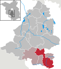 | |
 Dahme  Dahme | |
| Coordinates: 51°52′00″N 13°25′59″E / 51.86667°N 13.43306°E | |
| Country | Germany |
| State | Brandenburg |
| District | Teltow-Fläming |
| Municipal assoc. | Dahme/Mark |
| Subdivisions | 13 Ortsteile |
| Government | |
| • Mayor (2019–24) | Thomas Willweber[1] |
| Area | |
| • Total | 162.02 km2 (62.56 sq mi) |
| Elevation | 87 m (285 ft) |
| Population (2022-12-31)[2] | |
| • Total | 4,868 |
| • Density | 30/km2 (78/sq mi) |
| Time zone | UTC+01:00 (CET) |
| • Summer (DST) | UTC+02:00 (CEST) |
| Postal codes | 15936 |
| Dialling codes | 035451 |
| Vehicle registration | TF |
| Website | www.dahme.de |
Dahme (also: Dahme/Mark) is a town in the Teltow-Fläming district of Brandenburg, Germany. It is situated on the Dahme River, 30 km southeast of Luckenwalde, and 38 km west of Lübbenau.