Chkalovsk
Чкаловск
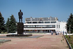
Monument to Valery Chkalov in front of the Palace of Culture and Sports
Flag of Chkalovsk
Coat of arms of Chkalovsk
Location of Chkalovsk
Map
Chkalovsk is located in Russia
Chkalovsk
Chkalovsk
Location of Chkalovsk
Chkalovsk is located in Nizhny Novgorod Oblast
Chkalovsk
Chkalovsk
Chkalovsk (Nizhny Novgorod Oblast)
Coordinates: 56°46′N 43°14′E / 56.767°N 43.233°E / 56.767; 43.233
CountryRussia
Federal subjectNizhny Novgorod Oblast[2]
Known since12th century
Town status since1955
Elevation
100 m (300 ft)
Population
 • Total12,368
 • Estimate 
(2018)[4]
11,462 (−7.3%)
 • Subordinated totown of oblast significance of Chkalovsk[2]
 • Capital oftown of oblast significance of Chkalovsk[1]
 • Urban okrugChkalovsk Urban Okrug[5]
 • Capital ofChkalovsk Urban Okrug[5]
Time zoneUTC+3 (MSK Edit this on Wikidata[6])
Postal code(s)[7]
606540, 606541, 606558
OKTMO ID22755000001
Websitegorodchkalovsk.ru
Chkalovsk population
2010 Census12,368[3]
2002 Census13,856[8]
1989 Census15,059[9]
1979 Census14,581[10]

Chkalovsk (Russian: Чка́ловск) is a town in Nizhny Novgorod Oblast, Russia, located on the right bank of the Volga River, 95 kilometers (59 mi) northwest of Nizhny Novgorod, the administrative center of the oblast. As of the 2010 Census, its population was 12,368.[3]

It was previously known as Vasilyeva Sloboda/Vasilyovo (until 1938). It was renamed after its most famous inhabitant, the war hero Valeri Chkalov.[11]

History

Vasilyeva Sloboda in the early 20th century

It has been known since the 12th century as Vasilyeva Sloboda, named so in honor of its founder Prince Vasily Yuryevich, the son of Yury Dolgoruky.[citation needed] For a long time the territory belonged to Prince Shuysky who eventually became Tsar Vasily Shuysky.

The famous Russian pilot Valery Chkalov was born in 1904 in Vasilyovo. In 1937, Vasilyovo was renamed Chkalovsk after him and in 1955 it was granted town status.[citation needed] Most of the original village was flooded by the Gorky Reservoir after the construction of Gorky Hydroelectric Station in 1955.

Administrative and municipal status

Within the framework of administrative divisions, it is, together with 228 rural localities, incorporated as the town of oblast significance of Chkalovsk—an administrative unit with the status equal to that of the districts.[2] As a municipal division, the town of oblast significance of Chkalovsk is incorporated as Chkalovsk Urban Okrug.[5]

Until May 2015, the town served as the administrative center of Chkalovsky District and, within the framework of administrative divisions, was incorporated within that district as a town of district significance.[12] As a municipal division, it was incorporated as Chkalovsk Urban Settlement within Chkalovsky Municipal District.[13]

References

Notes

  1. ^ a b Order #3-od
  2. ^ a b c Law #184-Z
  3. ^ a b c Russian Federal State Statistics Service (2011). Всероссийская перепись населения 2010 года. Том 1 [2010 All-Russian Population Census, vol. 1]. Всероссийская перепись населения 2010 года [2010 All-Russia Population Census] (in Russian). Federal State Statistics Service.
  4. ^ "26. Численность постоянного населения Российской Федерации по муниципальным образованиям на 1 января 2018 года". Federal State Statistics Service. Retrieved January 23, 2019.
  5. ^ a b c Law #59-Z
  6. ^ "Об исчислении времени". Официальный интернет-портал правовой информации (in Russian). June 3, 2011. Retrieved January 19, 2019.
  7. ^ Почта России. Информационно-вычислительный центр ОАСУ РПО. (Russian Post). Поиск объектов почтовой связи (Postal Objects Search) (in Russian)
  8. ^ Russian Federal State Statistics Service (May 21, 2004). Численность населения России, субъектов Российской Федерации в составе федеральных округов, районов, городских поселений, сельских населённых пунктов – районных центров и сельских населённых пунктов с населением 3 тысячи и более человек [Population of Russia, Its Federal Districts, Federal Subjects, Districts, Urban Localities, Rural Localities—Administrative Centers, and Rural Localities with Population of Over 3,000] (XLS). Всероссийская перепись населения 2002 года [All-Russia Population Census of 2002] (in Russian).
  9. ^ Всесоюзная перепись населения 1989 г. Численность наличного населения союзных и автономных республик, автономных областей и округов, краёв, областей, районов, городских поселений и сёл-райцентров [All Union Population Census of 1989: Present Population of Union and Autonomous Republics, Autonomous Oblasts and Okrugs, Krais, Oblasts, Districts, Urban Settlements, and Villages Serving as District Administrative Centers]. Всесоюзная перепись населения 1989 года [All-Union Population Census of 1989] (in Russian). Институт демографии Национального исследовательского университета: Высшая школа экономики [Institute of Demography at the National Research University: Higher School of Economics]. 1989 – via Demoscope Weekly.
  10. ^ Всесоюзная перепись населения 1979 г. Национальный состав населения по регионам России [All Union Population Census of 1979. Ethnic composition of the population by regions of Russia] (XLS). Всесоюзная перепись населения 1979 года [All-Union Population Census of 1979] (in Russian). 1979 – via Demoscope Weekly (website of the Institute of Demographics of the State University—Higher School of Economics.
  11. ^ Soviet Calendar: 1917-1947 (CCCP publication)
  12. ^ Order #3-od; revision prior to May 22, 2015
  13. ^ Law #149-Z

Sources