.mw-parser-output .hidden-begin{box-sizing:border-box;width:100%;padding:5px;border:none;font-size:95%}.mw-parser-output .hidden-title{font-weight:bold;line-height:1.6;text-align:left}.mw-parser-output .hidden-content{text-align:left}@media all and (max-width:500px){.mw-parser-output .hidden-begin{width:auto!important;clear:none!important;float:none!important))You can help expand this article with text translated from the corresponding article in French. (January 2009) Click [show] for important translation instructions.
View a machine-translated version of the French article.
Machine translation, like DeepL or Google Translate, is a useful starting point for translations, but translators must revise errors as necessary and confirm that the translation is accurate, rather than simply copy-pasting machine-translated text into the English Wikipedia.
Do not translate text that appears unreliable or low-quality. If possible, verify the text with references provided in the foreign-language article.
You must provide copyright attribution in the edit summary accompanying your translation by providing an interlanguage link to the source of your translation. A model attribution edit summary is Content in this edit is translated from the existing French Wikipedia article at [[:fr:Chassezac]]; see its history for attribution.
You may also add the template ((Translated|fr|Chassezac)) to the talk page.
For more guidance, see Wikipedia:Translation.
| Chassezac | |
|---|---|
 the Chassezac | |
 | |
| Location | |
| Country | France |
| Physical characteristics | |
| Source | |
| • location | in Saint-Frézal-d'Albuges |
| • coordinates | 44°35′30″N 03°46′47″E / 44.59167°N 3.77972°E |
| • elevation | 1,350 m (4,430 ft) |
| Mouth | |
• location | Ardèche |
• coordinates | 44°25′39″N 04°19′12″E / 44.42750°N 4.32000°E |
• elevation | 95 m (312 ft) |
| Length | 84.6 km (52.6 mi) |
| Basin size | 560 km2 (220 sq mi) |
| Discharge | |
| • average | 15.3 m3/s (540 cu ft/s) |
| Basin features | |
| Progression | Ardèche→ Rhône→ Mediterranean Sea |
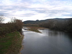
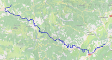
The Chassezac (French pronunciation: [ʃaszak]; Occitan: Chassesac) is an 84.6 km (52.6 mi) long river in the Lozère, Gard and Ardèche departments in southern France. It is a right tributary of the Ardèche.[1] Its source is in the commune of Saint-Frézal-d'Albuges, 2.8 km (1.7 mi) northeast of Les Chazeaux, the main hamlet in the commune. It flows generally southeast and flows into the Ardèche at Saint-Alban-Auriolles, 1.8 km (1.1 mi) east of the village itself.