| Pilatus | |
|---|---|
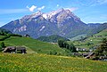
.jpg) Pilatus above Lake Lucerne | |
| Highest point | |
| Peak | Tomlishorn |
| Elevation | 2,128.5 m (6,983 ft) |
| Prominence | 585 m (1,919 ft)[1] |
| Parent peak | Brienzer Rothorn |
| Isolation | 16.7 km (10.4 mi)[2] |
| Coordinates | 46°58′26″N 8°14′28″E / 46.97389°N 8.24111°E |
| Naming | |
| Language of name | German |
| Geography | |
 Pilatus Location in Switzerland | |
| Country | Switzerland |
| Cantons | Nidwalden and Obwalden |
| Parent range | Emmental Alps |
| Topo map | Swiss Federal Office of Topography swisstopo |
| Climbing | |
| First ascent | 14th century |
| Easiest route | Pilatus Railway (world's steepest cogwheel railway) |
Pilatus, also often referred to as Mount Pilatus, is a 2,129 metre high mountain overlooking Lucerne in Central Switzerland. It is on the border between the cantons of Lucerne, Nidwalden and Obwalden. The Pilatusbahn brings people close to the summit of the mountain at 2,073 metres and is the steepest cogwheel railway in the world.
Gallery
[change | change source]-
 View of Lucerne and Lake Lucerne from the summit.
 -
 Pilatus seen from the southeast.
 -
 Pilatusbahn on its way to the top.


_(4444425461).jpg)
References
[change | change source]- ↑ Retrieved from the Swisstopo topographic maps. The key col is the Glaubenberg Pass (1,543 m).
- ↑ Retrieved from Google Earth. The nearest point of higher elevation is north of the Widderfeld Stock.