Wacousta, Michigan | |
|---|---|
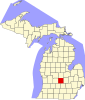
 Location within Clinton County | |
 Wacousta Location within the state of Michigan  Wacousta Location within the United States | |
| Coordinates: 42°49′13″N 84°41′27″W / 42.82028°N 84.69083°W[1] | |
| Country | United States |
| State | Michigan |
| County | Clinton |
| Township | Watertown |
| Area | |
| • Total | 8.99 sq mi (23.29 km2) |
| • Land | 8.91 sq mi (23.09 km2) |
| • Water | 0.08 sq mi (0.20 km2) |
| Elevation | 824 ft (251 m) |
| Population (2020) | |
| • Total | 1,532 |
| • Density | 171.85/sq mi (66.35/km2) |
| Time zone | UTC-5 (Eastern (EST)) |
| • Summer (DST) | UTC-4 (EDT) |
| ZIP code(s) | |
| Area code | 517 |
| FIPS code | 26-82680[3] |
| GNIS feature ID | 2583768[1] |
Wacousta is an unincorporated community and census-designated place (CDP) in Clinton County in the U.S. state of Michigan. The CDP is located within Watertown Charter Township. As of the 2010 census, it had a population of 1,440.[4]