Mouser, Oklahoma | |
|---|---|
 Mouser, Oklahoma | |
| Coordinates: 36°52′14″N 101°24′55″W / 36.87056°N 101.41528°W[1] | |
| Country | United States |
| State | Oklahoma |
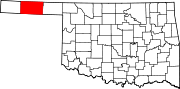
| County | Texas |
| Elevation | 3,127 ft (953 m) |
| Time zone | UTC-6 (Central (CST)) |
| • Summer (DST) | UTC-5 (CDT) |
| Area code | 580 |
| GNIS feature ID | 1100652[1] |
Mouser is an unincorporated community in Texas County, Oklahoma, United States. Mouser is 13.5 miles (21.7 km) north-northeast of Guymon and 11 miles (18 km) west of Hooker. The community of Straight is two miles to the west.[2] The Beaver, Meade and Englewood Railroad (BM&E) reached the locale in the summer of 1928,[3] and two grain elevators in Mouser, the Mouser Grain Elevator and the Mouser Woodframe Grain Elevator/Collingwood Elevator, which were built along the BM&E's tracks, are now listed on the National Register of Historic Places listings in Texas County, Oklahoma.[4]