Size of this preview: 800 × 549 pixels. Other resolutions: 320 × 220 pixels | 640 × 439 pixels | 1,024 × 703 pixels | 1,280 × 878 pixels | 2,036 × 1,397 pixels.
Original file (2,036 × 1,397 pixels, file size: 180 KB, MIME type: image/png)
| This is a file from the Wikimedia Commons. Information from its description page there is shown below. Commons is a freely licensed media file repository. You can help. |

|
This historical map image could be re-created using vector graphics as an SVG file. This has several advantages; see Commons:Media for cleanup for more information. If an SVG form of this image is available, please upload it and afterwards replace this template with
((vector version available|new image name)).
It is recommended to name the SVG file “Prima tetrarchia Diocletianus.svg”—then the template Vector version available (or Vva) does not need the new image name parameter. |
Summary
| Description |
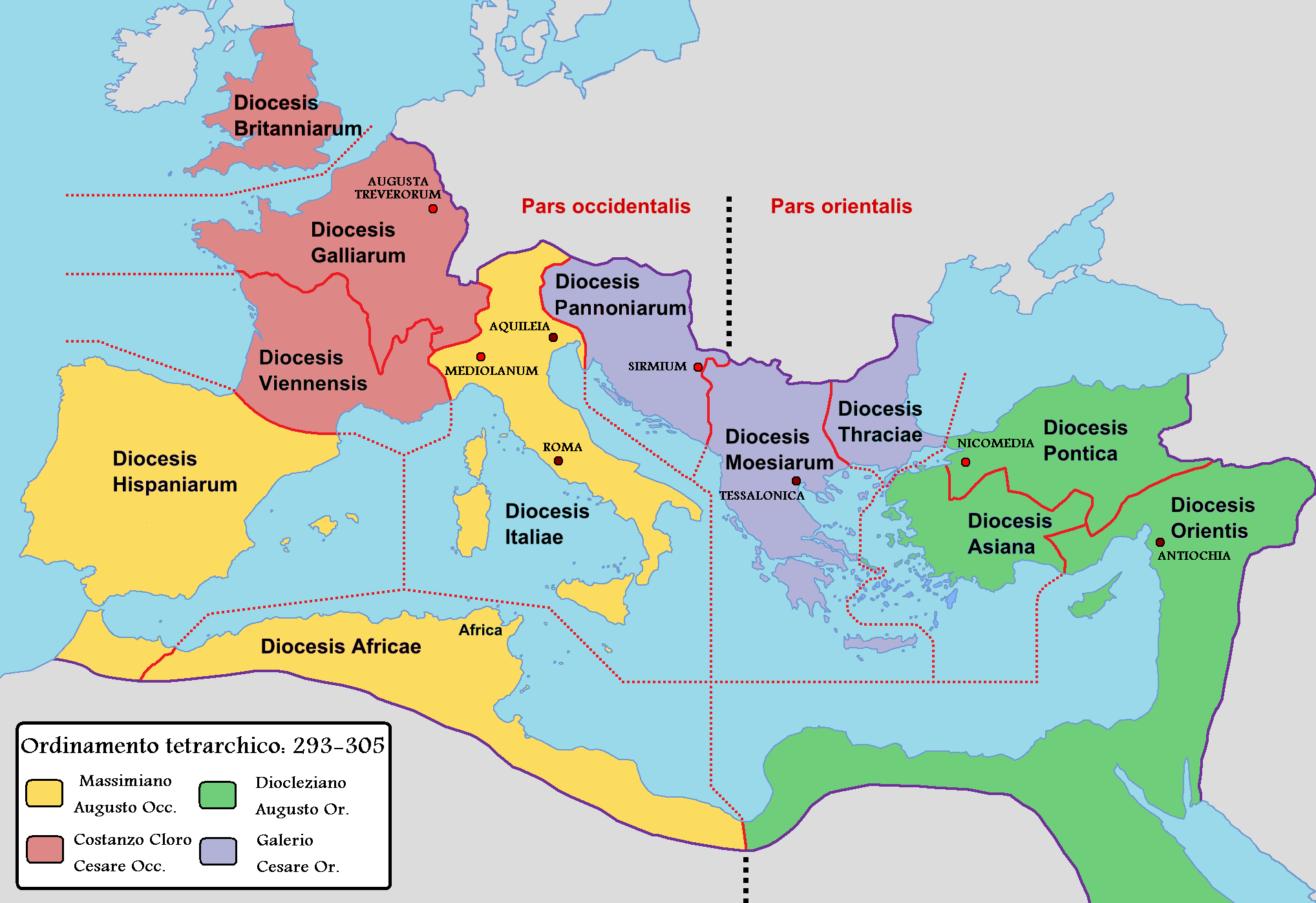
English: Map of the Roman Empire with dioceses created by Diocletien. Italiano: Mappa dell'Impero romano durante la prima tetrarchia di Diocleziano. |
||
| Date | |||
| Source |
|
||
| Author |
|
Licensing
I, the copyright holder of this work, hereby publish it under the following license:
| I, the copyright holder of this work, release this work into the public domain. This applies worldwide. In some countries this may not be legally possible; if so: I grant anyone the right to use this work for any purpose, without any conditions, unless such conditions are required by law. |
Original upload log
This image is a derivative work of the following images:
- File:Roman Empire with dioceses in 300 AD.png licensed with PD-self
- 2009-03-10T12:34:18Z Mandrak 2052x1414 (223180 Bytes) Erreurs corrigées.
- 2009-03-03T20:03:56Z Mandrak 2052x1414 (223409 Bytes) ((Information |Description=((en|1=Map of the Roman Empire with dioceses created by Diocletien.)) ((fr|1=Carte de l'Empire romain avec les diocèses créés par l'empereur Dioclétien.)) |Source=travail personnel (own work) |A
Uploaded with derivativeFX
