Berjou
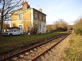
The railway station in Berjou
Location of Berjou
Map
Berjou is located in France
Berjou
Berjou
Berjou is located in Normandy
Berjou
Berjou
Coordinates: 48°51′01″N 0°28′51″W / 48.8503°N 0.4808°W / 48.8503; -0.4808
CountryFrance
RegionNormandy
DepartmentOrne
ArrondissementArgentan
CantonAthis-Val de Rouvre
IntercommunalityCA Flers Agglo
Government
 • Mayor (2020–2026) Didier Vieceli[1]
Area
1
8.82 km2 (3.41 sq mi)
Population
 (2021)[2]
437
 • Density50/km2 (130/sq mi)
Time zoneUTC+01:00 (CET)
 • Summer (DST)UTC+02:00 (CEST)
INSEE/Postal code
61044 /61430
Elevation58–257 m (190–843 ft)
(avg. 200 m or 660 ft)
1 French Land Register data, which excludes lakes, ponds, glaciers > 1 km2 (0.386 sq mi or 247 acres) and river estuaries.

Berjou (French pronunciation: [bɛʁʒu] ) is a commune in the Orne department in northwestern France.

Geography

The commune is part of the area known as Suisse Normande.[3]

The commune is made up of the following collection of villages and hamlets, Cambercourt,Les Oiseaux, Les Cours,Le Hamel, La Trollière, Le Fang, Vervent and Berjou.[4]

The commune has the river Noireau running through it.

Population

Historical population
YearPop.±% p.a.
1968 473—    
1975 522+1.42%
1982 535+0.35%
1990 525−0.24%
1999 508−0.37%
2009 475−0.67%
2014 492+0.71%
2020 446−1.62%
Source: INSEE[5]

Places of interest

Notre-Dame church in Berjou

See also

References

  1. ^ "Répertoire national des élus: les maires". data.gouv.fr, Plateforme ouverte des données publiques françaises (in French). 2 December 2020.
  2. ^ "Populations légales 2021" (in French). The National Institute of Statistics and Economic Studies. 28 December 2023.
  3. ^ "Map of Suiss Normande" (PDF).
  4. ^ a b "Google Maps". Google Maps.
  5. ^ Population en historique depuis 1968, INSEE
  6. ^ "Histoire. Le musée de la Libération de Berjou va rouvrir, samdi 6 juin 2020". actu.fr. 7 May 2020.
  7. ^ "D-Day landings: Remembering the Battle of Berjou". 9 June 2014 – via www.bbc.co.uk.